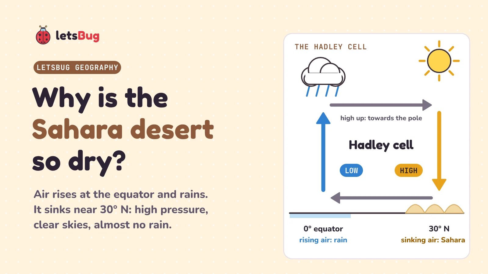
The Sahara is so dry because it sits under sinking air. Near the equator (the middle of the Earth), strong sunshine heats the air, so it rises, cools and drops its rain. High up, it moves towards the poles and sinks at about 30° north. Sinking air warms up, so clouds can't form: high pressure, clear skies, almost no rain.
In this post we start with two real cities, one almost rainless and one soaked, and work out why. Along the way: what air pressure is, the myth about which way wind blows, the giant loop of air called the Hadley cell, the three-cell model in AQA's GCSE Geography, and why the trade winds blow from the north-east (Christopher Columbus used them in 1492). Then we write the full exam answer to "why is the Sahara dry?" step by step, and try one problem with real rainfall data. Every hard word is explained the first time it comes up.
Key takeaways
- Air pressure is the weight of all the air above you, pressing down. At sea level it's about 1013 hPa (hectopascals, the unit on weather maps).
- Rising air means low pressure, clouds and rain. Sinking air means high pressure and clear skies.
- Wind blows from high pressure to low pressure, never the other way. The bigger the difference, the stronger the wind.
- In the Hadley cell, air rises at the equator and sinks at about 30° north and south. The Sahara and the Arabian Desert sit under that sinking air.
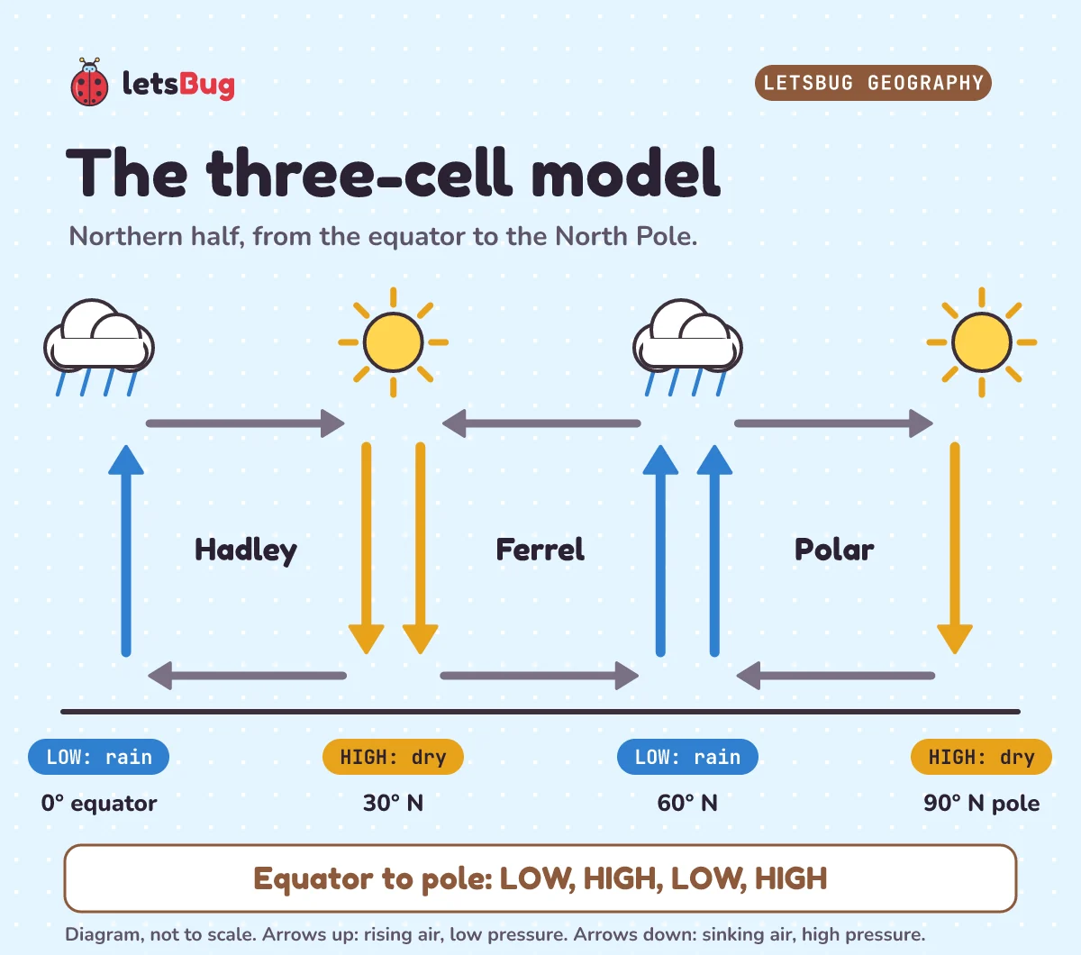
- The three-cell model has Hadley (0 to 30°), Ferrel (30 to 60°) and Polar (60 to 90°) cells in each half of the Earth. From the equator to the pole: low, high, low, high.
- The Coriolis effect (the Earth's spin bending moving air) turns the air flowing back to the equator into the north-east and south-east trade winds.
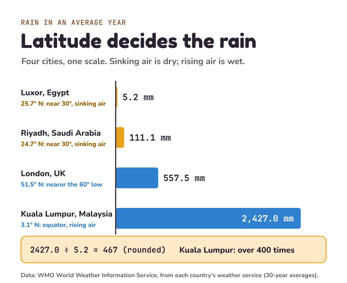
- Real rainfall in an average year: Luxor, in the Sahara, gets 5.2 mm; Kuala Lumpur, near the equator, gets 2,427 mm, more than 400 times as much.
- "It's hot and sunny" only describes a desert: it says what it's like. To explain it, say why, with a chain of causes: rise, sink, warm, dry.
This post goes with letsBug Geography, episode 4. It covers the general atmospheric circulation model, which is part of the weather hazards topic in AQA's GCSE Geography. Watch the lesson, or read on: the post adds the rainfall data in full, a model answer built as a chain of causes, and worked answers to every practice question.
How dry is the Sahara?
Very dry. Luxor is a city in Egypt, in the Sahara, on the river Nile. In an average year it gets about 5.2 mm of rain. If a whole year's rain stayed where it fell, it would make a puddle only about 5 mm deep. Kuala Lumpur, in Malaysia, gets about 2,427 mm: a puddle about 2.4 metres deep, taller than most adults. That's more than 400 times as much rain (2,427 ÷ 5.2 = 467, rounded).
Both numbers are 30-year averages from each country's national weather service, collected by the World Meteorological Organization (WMO), which gathers weather data from countries around the world. Averaging 30 years means one unusually wet or dry year doesn't change the answer much, the same way a climate graph does.
Both cities are warm. Both are much closer to the equator (the imaginary line around the middle of the Earth, at 0° latitude) than to the poles. Latitude is how far north or south of the equator a place is, measured in degrees: Kuala Lumpur is at 3.1° N, and Luxor at 25.7° N.
So why is one almost rainless, and the other soaked? The answer is a set of giant loops of air that wrap around the whole planet. Geographers call this global atmospheric circulation. The Met Office, the UK's national weather service, defines it: "Global atmospheric circulation refers to the large-scale movement of air that redistributes heat and moisture around the planet." In other words, moving air carries heat and water from one part of the world to another.
What is air pressure?
Air feels like nothing, but it has weight. Air pressure is the weight of all the air above you, pressing down on the ground. Think of lying under a pile of blankets: the more blankets on top, the harder they press. The Met Office puts it this way: "Atmospheric pressure is the force exerted by the Earth's atmosphere on its surface, measured in hectoPascals (hPa)" (The atmosphere is the layer of air around the Earth.)
At sea level, it averages about 1013 hPa. A hectopascal is just the unit of pressure you'll see on weather maps, the same way a millimetre is a unit of length. The Met Office: "Standard sea-level pressure is 1013 hPa".
Here's the key idea for the whole topic:
- When air rises, it presses down less, so the pressure at the ground is low. Rising air cools, and the Met Office says "The rising air cools, causing water vapour to condense into clouds and precipitation." (Water vapour is water as an invisible gas, and to condense is to turn back into tiny droplets of liquid. Precipitation means rain, snow or hail: water falling from the sky.)
- When air sinks, it presses down more, so the pressure is high. "The descending air reduces cloud formation, resulting in settled weather." (Descending means going down; settled weather means calm and dry.)
Does wind blow from high to low pressure?
Yes. A common myth says wind blows from low pressure to high pressure. It's the other way round. Think of a bicycle tyre. Open the valve, and air rushes out, from the high pressure inside to the low pressure outside. The atmosphere works the same way. Wind is air moving from high pressure to low pressure. The Met Office: "Wind is driven by the pressure gradient force, moving from high to low pressure regions."
The bigger the difference in pressure, the stronger the wind: "The greater the difference in pressure (the pressure gradient), the stronger the wind." A pressure gradient is just how quickly the pressure changes from one place to the next, like how steep a hill is. Water runs faster down a steep hill, and air rushes faster across a big pressure difference. So: high to low, like water running downhill.
Why does it rain so much at the equator?
Start at the equator. Here the sun is almost overhead, so the land and sea heat up the most. The Met Office notes the temperature difference this creates "between the equator (which receives more direct sunlight) and the poles (which receive less)". The warm air near the ground rises, a bit like the hot air in a hot-air balloon, and that leaves low pressure at the surface.
As the air rises, it cools. Cool air can't hold as much water vapour, which is water as an invisible gas. So the vapour condenses: it turns back into tiny droplets of liquid water, the same way drops form on a cold glass of water on a hot day. Masses of those droplets make clouds. The clouds grow tall, and they bring heavy rain and thunderstorms. That's why places near the equator, like Kuala Lumpur at 3.1° N, are so wet: about 2,427 mm of rain in an average year.
What is the Hadley cell?
The rising air can't keep going up forever. High in the sky, it spreads out towards the poles. By about 30° north and south, it has cooled, and it sinks back down. Sinking air means high pressure. As it sinks it's squeezed by the air around it, and squeezed air warms up, the same way air gets warm when you squash it in a bicycle pump. Warm air can hold its water vapour, so clouds can't form. The result: clear skies and almost no rain.
That's exactly where you find the Sahara, and the Arabian Desert. The Met Office describes the Hadley cell's air "sinking over subtropical regions, creating high-pressure regions over the subtropical oceans and deserts like the Sahara." (The tropics are the hot band of the Earth either side of the equator. Subtropical means the regions just outside it, around 30° north and south.)
Then the air flows back along the surface to the equator, from high pressure to low, and the loop starts again. This whole loop is called the Hadley cell: a cell here just means one giant loop of moving air. The Met Office sums up the loop in one sentence: "Air rises along the ITCZ, moves toward the poles, and descends in the subtropics, forming the Hadley Cell." The ITCZ, or Inter-Tropical Convergence Zone, is the band of low pressure near the equator where the rising air is. Converge means come together: the winds from the north and from the south meet there.
What is the three-cell model?
The full model has three loops in each hemisphere, each half of the planet (north or south of the equator):
- The Hadley cell runs from the equator to about 30°.
- The Ferrel cell runs from 30° to 60°. It turns the opposite way: air rises at 60° and sinks at 30°.
- The Polar cell runs from 60° to the pole.
Real air doesn't stop at exact lines. The Met Office says the Hadley cell "Extends from the equator to about 30–40° latitude", and the Ferrel cells are "Found between 30–40° and 60–70° latitude." The GCSE model rounds these to 30° and 60°, so use those numbers in an exam.
How do you read the three-cell model diagram?
- Find where the arrows point up. That means rising air: low pressure, clouds and rain. That's at the equator and at about 60°.
- Find where the arrows point down. That means sinking air: high pressure and dry air. That's at about 30° and at the pole.
- Say the pattern from the equator to the pole: low, high, low, high. These bands are the pressure belts.
Now you can predict whether a place is likely to be wet or dry, on average, from its latitude. A place near 30° is likely to be dry. A place near the equator or near 60° is likely to be wet. The Met Office: "This system shapes prevailing winds and the distribution of deserts and rainforests around the world." (Prevailing winds are the winds that blow most often in a place.)
Why do the trade winds blow from the north-east?
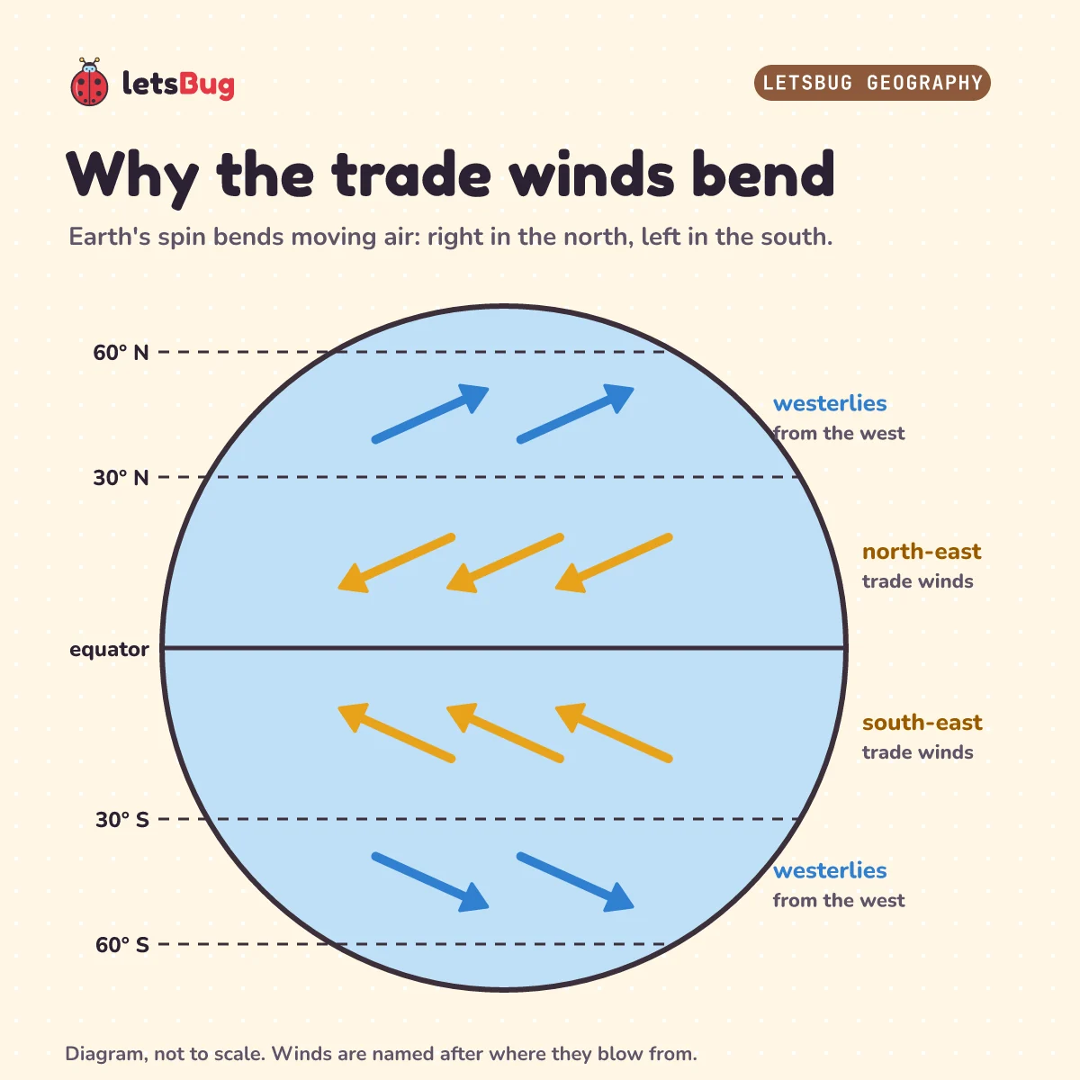
There's one more thing to add. The Earth spins, and that bends moving air. This is called the Coriolis effect. Picture rolling a ball across a spinning playground roundabout (a merry-go-round): to someone standing on it, the ball's path curves. The Met Office says the Coriolis effect "deflects moving air to the right in the northern hemisphere and to the left in the southern hemisphere." (Deflects means pushes it off its straight path.)
So the surface air flowing back to the equator in the Hadley cell doesn't blow straight from the north. It's bent to the right, so it blows from the north-east. South of the equator it's bent to the left, so it blows from the south-east. These are the trade winds. Wikipedia: "The trade winds blow mainly from the northeast in the Northern Hemisphere and from the southeast in the Southern Hemisphere".
Be careful with wind names. Winds are named for the direction they blow from, so a north-east wind comes from the north-east and blows towards the south-west. In the Ferrel cell, the surface air flows towards the poles and is bent too, so it blows from the west: these are the westerlies.
How did Columbus use the trade winds?
"Trade winds have been used by captains of sailing ships to cross the world's oceans for centuries." In 1492, Christopher Columbus planned his first voyage across the Atlantic around them. Wikipedia: "He planned to first sail to the Canary Islands before continuing west by utilizing the northeast trade wind." So he sailed south to the Canary Islands first, to reach the trade winds, and only then turned west.
The dates show how well it worked. "On 6 September the ships departed San Sebastián de La Gomera", a port in the Canary Islands. "They landed on the morning of 12 October", on an island Columbus named San Salvador. Nobody knows for sure which island that was, but historians think it was probably one in the Bahamas. From 6 September to 12 October is 24 days left in September plus 12 in October: 36 days sailing with the north-east trade winds behind them.
To get home he couldn't sail straight back into the same wind. He headed further north, into the westerlies, which blow from the west towards Europe. "On 16 January 1493, the homeward journey began."
Why is the Sahara dry? How to write the full answer
This is the classic exam question: Why does the Sahara Desert get so little rain? There's a weak answer and a strong one.
A weak answer says: it's hot and sunny, so it doesn't rain. That only describes the desert. It doesn't explain it. In an exam, "describe" means say what something is like; "explain" means say why it happens. An explanation is a chain of causes, where each step leads to the next:
- Rise: at the equator, intense heating makes the air rise (low pressure), and high up it moves towards the poles.
- Sink: at about 30° north, that air sinks, which creates high pressure.
- Warm: sinking air is squeezed and warms up, so clouds can't form.
- Dry: with so few clouds, there's very little rain, and the Sahara sits right under this sinking air of the Hadley cell.
Four linked steps, and each one leads to the next: that's what makes it a strong explanation. Joining words like "so", "which" and "because" show the examiner the links.
Where would you build a solar farm?
Try this one. An energy company wants to build a solar farm (a big field of solar panels) where the skies are clearest. It's choosing between three cities: Kuala Lumpur at 3.1° N, Riyadh in Saudi Arabia at 24.7° N, and London at 51.5° N. Using only the circulation model, which city should it pick, and why? Decide before you read on.
Riyadh. It sits close to 30° N, under sinking air and high pressure, so the skies are mostly clear. Kuala Lumpur is under the rising air near the equator, and London is nearer the low-pressure belt at 60°. Less rain means fewer clouds, so the rainfall data is a good clue, and it agrees: Riyadh gets about 111 mm a year, London about 558 mm, and Kuala Lumpur about 2,427 mm.
Your turn. These are the three practice questions from the video. Try each one before you open the answers.
1) Using the three-cell model, identify the pressure at 30° N and at 60° N.
2) Why does the Sahara Desert receive very little rainfall?
3) Why do the trade winds in the northern hemisphere blow from the north-east?
Show the answers
1) High pressure at 30° N, because air sinks there. Low pressure at 60° N, because air rises there.
2) Give the chain of causes. Intense heating at the equator makes air rise (low pressure) and flow towards the poles high up. The air sinks at about 30° N, creating high pressure. Sinking air warms as it's squeezed, so clouds can't form. With no clouds there's very little rain, and the Sahara lies under this sinking air of the Hadley cell. "It's hot and sunny" on its own is a description, not an explanation.
3) Surface air flows from the high pressure at about 30° N towards the low pressure at the equator. The Coriolis effect bends it to the right in the northern hemisphere, so it arrives from the north-east.
Exam-style questions with model answers
The number in brackets is the marks. Each mark is one clear point.
Q1. What is air pressure? [1]
Model answer
The force (weight) of the atmosphere pressing down on the Earth's surface, measured in hectopascals (hPa) [1].
Q2. State the direction in which surface winds blow between areas of different pressure. [1]
Model answer
From high pressure to low pressure [1]. Low to high is the classic wrong answer.
Q3. Name the cell of atmospheric circulation found between 30° and 60° N. [1]
Model answer
The Ferrel cell [1].
Q4. Explain why the Sahara Desert receives very little rainfall. [4]
Model answer
Intense heating at the equator makes air rise and move towards the poles high up [1]. The air sinks at about 30° N, creating high pressure [1]. Sinking air warms as it's squeezed, so clouds can't form [1]. With almost no cloud there's very little rain, and the Sahara lies under this sinking air of the Hadley cell [1].
Q5. Suggest why Riyadh (24.7° N) gets less rain than London (51.5° N). [2]
Model answer
Riyadh is close to 30° N, under the sinking air of the Hadley cell, so it has high pressure and clear skies [1]. London is nearer 60° N, where air rises in the low-pressure belt, so clouds and rain form more often [1]. Rainfall data: about 111 mm a year in Riyadh, about 558 mm in London.
Questions people ask
Why is the Sahara a desert?
Because it sits under sinking air at about 30° north. Air that rose at the equator sinks there, creating high pressure. Sinking air warms, so clouds can't form, and there's almost no rain. Luxor, in the Sahara, gets about 5.2 mm of rain a year.
What is a Hadley cell?
A giant loop of air between the equator and about 30° north or south. Air rises at the equator, flows towards the pole high up, sinks at about 30°, and flows back along the surface as the trade winds.
Does wind blow from high to low pressure?
Yes. Wind is air moving from high pressure to low pressure, like air rushing out of a tyre's open valve. The bigger the pressure difference, the stronger the wind.
Why is there low pressure at the equator?
The sun is almost overhead, so the ground and sea heat the air strongly. The warm air rises, and rising air presses down less on the surface, so the pressure is low. The rising air cools and makes clouds and heavy rain.
What are the three cells of atmospheric circulation?
The Hadley cell (equator to about 30°), the Ferrel cell (30° to 60°) and the Polar cell (60° to the pole), in each hemisphere. From the equator to the pole, the pressure belts go low, high, low, high.
What are the trade winds?
The surface winds that blow back towards the equator in the Hadley cell. The Coriolis effect bends them, so they blow from the north-east north of the equator and from the south-east south of it. Sailing ships, including Columbus's in 1492, used them to cross the Atlantic.
Keep going
- Watch the full lesson, Why Is the Sahara Desert So Dry? Hadley Cells Explained, or the one-minute Short: Why Does Wind Blow? High to Low Pressure, and Why the Sahara Is Dry. More in letsBug Geography on YouTube.
- Read the rainfall bars and temperature line for a real wet place and a real desert: how to read a climate graph (episode 3).
- Earlier in the series: why do earthquakes and volcanoes happen? (plate tectonics). Next: tropical cyclones, and whether they spin the same way on both sides of the equator.
Checked on 26 October 2026 against the 9 sources below. Every rainfall total was added up again from the 12 monthly values in WMO's data files, every ratio and date gap was worked out in a Python script, and every quote was matched word for word with the source text.
Sources
- AQA: GCSE Geography 8035 specification, Living with the physical environment (3.1.1.3 Weather hazards)
- Met Office: Global circulation patterns (the three-cell model, the Coriolis effect)
- Met Office: High and low pressure (air pressure, rising and sinking air, wind, the ITCZ)
- WMO World Weather Information Service: Luxor (Egyptian Meteorological Authority, 1981–2010), Kuala Lumpur (Malaysian Meteorological Department, 1971–2000), Riyadh (National Center for Meteorology, 1982–2011) and London (Met Office, 1981–2010)
- Wikipedia: Trade winds and Voyages of Christopher Columbus