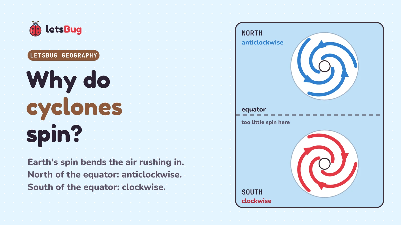
Cyclones spin because the Earth spins. Air rushes in towards the low pressure at the centre of the storm, and the Coriolis effect bends it: to the right north of the equator, to the left south of it. So cyclones, hurricanes and typhoons turn anticlockwise in the northern half of the Earth and clockwise in the southern half.
In this post we start with a real storm, Cyclone Phailin, which hit India in October 2013, and work out how a storm like that is born, why it spins, and what is inside it. Along the way: why cyclones almost never form on the equator, the myth about sinks in Australia, how to read a cyclone's path on a map, the three ways a cyclone does harm, and how one Indian state cut its death toll from nearly 10,000 people to 38. Every hard word is explained the first time it comes up.
Key takeaways
- A tropical cyclone is a huge spinning storm with very low air pressure (the weight of the air pressing down) at its centre. Around India and Australia it's a cyclone, in the Atlantic a hurricane, in the north-west Pacific a typhoon. Same storm, different names.
- It needs warm sea water (about 26.5 to 27 °C or warmer, down to about 50 m), moist air, and at least 500 km of distance from the equator.
- It grows because water vapour (water as an invisible gas) condenses, turning into tiny drops of cloud, and gives out heat. The heat makes the air rise faster, so more air rushes in across the sea.
- The Coriolis effect (the Earth's spin bending moving air) bends that in-rushing air, so cyclones spin anticlockwise in the north and clockwise in the south. Near the equator it's too weak, so cyclones almost never form there.
- The calm eye has the lowest pressure. The eyewall around it has the strongest winds. Spiral rain bands trail outside.
- Three hazards (dangers): strong wind, heavy rain and floods, and the storm surge, the sea pushed onto the land.
- Odisha, India: nearly 10,000 deaths in the 1999 super cyclone, 38 in Cyclone Phailin (2013), after a warning 4 to 5 days ahead and almost a million people moved to safety.
This post goes with letsBug Geography, episode 5. It covers tropical storms: part of the weather hazards topic in AQA's GCSE Geography, and of the cyclones and early warning systems topic in the CBSE Class 9 Social Science curriculum. Watch the lesson, or read on. The post adds the official figures from India's weather service (IMD), a track map (a map of the storm's path) you can read yourself, the scales used to grade cyclones, and worked answers to every practice question.
What happened when Cyclone Phailin hit India?
On the night of 12 October 2013, Cyclone Phailin crossed the coast of Odisha, a state on India's east coast, near the town of Gopalpur. The India Meteorological Department (IMD), India's national weather service, says the strongest steady wind at landfall was "about 115 knots (215 kmph)". A knot is the unit of speed used at sea and by weather forecasters, so that's about 215 kilometres an hour. Landfall means the moment the centre of the storm reaches the coast.
Fourteen years earlier, on 29 October 1999, an even stronger storm hit the same coast, near the port of Paradip. It's called the Odisha super cyclone. IMD's science journal, Mausam, says it "took away valuable lives of nearly 10,000 people". Phailin was the strongest storm to reach India's coast after that one. IMD's report on it says: "VSCS PHAILIN is the most intense cyclone that crossed India coast after Odisha Super Cyclone of 29th October 1999."
This time, Odisha's death toll was 38. IMD's report lists 21 deaths caused by the cyclone and 17 caused by the floods after it: 21 + 17 = 38. The coast was the same and the storm was similar, so what changed? We answer that near the end of this post.
What is a tropical cyclone?
A tropical cyclone is a huge spinning storm that forms over warm seas in the tropics (the hot band of the Earth on either side of the equator). At its centre the air pressure, the weight of the air above pressing down, is very low. Low pressure at the ground means the air there is rising, as we saw in why the Sahara desert is so dry.
IMD's own definition, in plain words: a spinning area of low pressure in the tropics, where the pressure at the centre is 5 to 6 hPa below the air around it and the steady wind reaches 34 knots (about 62 km/h). hPa (hectopascals) is the unit of pressure on weather maps. Maximum sustained wind means the strongest wind that keeps blowing steadily, not a short gust: IMD averages it over 3 minutes. And these storms are big. IMD calls a cyclone "a vast violent whirl of 150 to 800 km".
Cyclone, hurricane or typhoon: what's the difference?
Only the place. NOAA, the US weather and oceans agency, puts it simply: "The only difference between a hurricane and a typhoon is the location where the storm occurs."
- Hurricane: in the North Atlantic and the central and eastern North Pacific.
- Typhoon: in the north-west Pacific.
- Cyclone or tropical cyclone: around India, in the Bay of Bengal and the Arabian Sea, and in the South Pacific and Indian Ocean, around Australia. NOAA: "in the South Pacific and Indian Ocean, the generic term tropical cyclone is used". IMD says the words hurricane and typhoon are just "region specific names" for a strong tropical cyclone.
Around India, they're not rare. In an average year, IMD says, 5 or 6 cyclonic storms form over the north Indian Ocean, and 2 or 3 of them become severe. NOAA adds that here they come "from April to December, with a double peak of activity in May and November". Phailin, in October, came inside that season, a month before the November peak.
How do hurricanes form?
A cyclone needs three main things, the same for a hurricane or a typhoon:
- Warm sea water. NOAA says "at least 80 °F / 27 °C" down to a depth of about 46 m. IMD gives at least 26.5 °C, down to "at least on the order of 50 m". Under Phailin, IMD measured the sea at about 28 to 29 °C.
- Moist air. The air must be fairly moist, even about 5 km up.
- Distance from the equator: "A minimum distance of at least 500 km from the equator", says IMD. We'll see why in a moment.
Then the storm grows in a loop, a bit like a bonfire: its hot air rises, and fresh air rushes in at the bottom to feed it.
- Evaporate: water from the warm sea evaporates (turns into vapour), and the warm, moist air rises.
- Condense: as it rises, the air cools, and the vapour condenses: it turns back into tiny drops of water, which build tall clouds. Condensing gives out heat. NOAA: "In the process of condensation, heat is released. This heat warms the atmosphere, making the air lighter, which then continues to rise."
- Low pressure: the air rises faster, so the pressure at the sea surface falls even more. IMD says the same: the heat from condensation warms the air, and the pressure falls further.
- Rush in: wind always blows from high pressure to low pressure. The Met Office, the UK's national weather service: "Wind is driven by the pressure gradient force, moving from high to low pressure regions." So air rushes in across the sea towards the centre. NOAA says that as the warm air rises, "more air moves in near the surface to take its place, which is the strong wind we feel from these storms."
- Feed: the new air picks up more water vapour from the warm sea, and the loop starts again. The storm feeds itself.
That's also why a cyclone dies over land. Once the centre of the storm moves over land, NOAA says, "it will begin to weaken rapidly, not because of friction, but because the storm lacks the moisture and heat that the ocean provided." Phailin shows it. Its steady wind was 115 knots when it crossed the coast, at 1700 UTC on 12 October. Seven hours later, at 0000 UTC on 13 October, it was down to 75 knots. (UTC is the world's standard clock for weather data. Indian time is 5 hours 30 minutes ahead of it, so 1700 UTC was 10:30 pm in India.)
Why do cyclones spin?
Because the Earth spins. Picture rolling a ball across a spinning playground roundabout (a merry-go-round). To someone standing on it, the ball's path curves. The Earth is a giant spinning roundabout, so air that travels a long way across it curves too. This is the Coriolis effect. IMD: "The reason is that the earth's rotation sets up an apparent force (called the Coriolis force) that pulls the winds to the right in the Northern Hemisphere (and to the left in the Southern Hemisphere)." (A hemisphere is half of the Earth, north or south of the equator.)
Now put that together with the in-rushing air. Each stream of air heads for the low pressure at the centre, but gets pulled to the right of the way it's moving. So it misses the centre a little and swings round it. Air coming from the south passes on the east side of the centre, going north. Air coming from the north passes on the west side, going south. Together they turn the whole storm anticlockwise. IMD: "the surface winds will flow inward trying to fill in the low and will be deflected to the right and a counter-clockwise rotation will be initiated." (Counter-clockwise is the American word for anticlockwise. Deflected means pushed off its straight path.)
South of the equator everything is pulled to the left instead, so cyclones there spin clockwise. NOAA says the same: "Air spirals in toward the center in a counter-clockwise pattern in the northern hemisphere (clockwise in the southern hemisphere) and out the top in the opposite direction." (High up, the air spreads out and turns the other way. At the surface, where we live, the spin is anticlockwise in the north.) The same bending turns the trade winds, the steady winds that blow towards the equator: see how the Coriolis effect turns the trade winds.
Why don't cyclones form on the equator?
Because the Coriolis effect is too weak near the equator to start the spin, and a storm that can't spin can't hold on to its low pressure. IMD: "Without the Coriolis force, the low pressure of the disturbance cannot be maintained. This is the reason why the narrow corridor of width of about 300 km on either side of the equator is free from cyclones." The sea there is warm enough. The spin is missing.
NOAA puts it in degrees of latitude (how far north or south of the equator a place is): "However, with only the rarest exceptions, these storms do not form within 5° latitude of the equator." It also names one rare exception: Typhoon Vamei, which formed near Singapore on 27 December 2001. Vamei's centre was at 1.5° N, so close to the equator that its winds reached across it.
One more thing follows. A cyclone can't cross the equator either, because near it the storm loses the spin that keeps it going. IMD says no tropical cyclone moves across the equator from one half of the Earth to the other.
Does water drain the other way in Australia?
No. This is a myth. The Coriolis effect only matters for things that are huge or travel a long way, like a storm hundreds of kilometres across. IMD says the Coriolis force is far too tiny to turn the water going down the drains of sinks and toilets. The way a sink drains depends on its shape and on how the water was already moving when you pulled the plug. IMD again: "Thus, one can find both clockwise and counter-clockwise flowing drains no matter what hemisphere you are located." Try it at home: fill a sink, wait for the water to go still, and pull the plug. Then fill it again, swirl the water clockwise and pull the plug. Then try it swirled anticlockwise.
What is inside a cyclone?
NOAA: "The main parts of a tropical cyclone are the rainbands, the eye, and the eyewall."
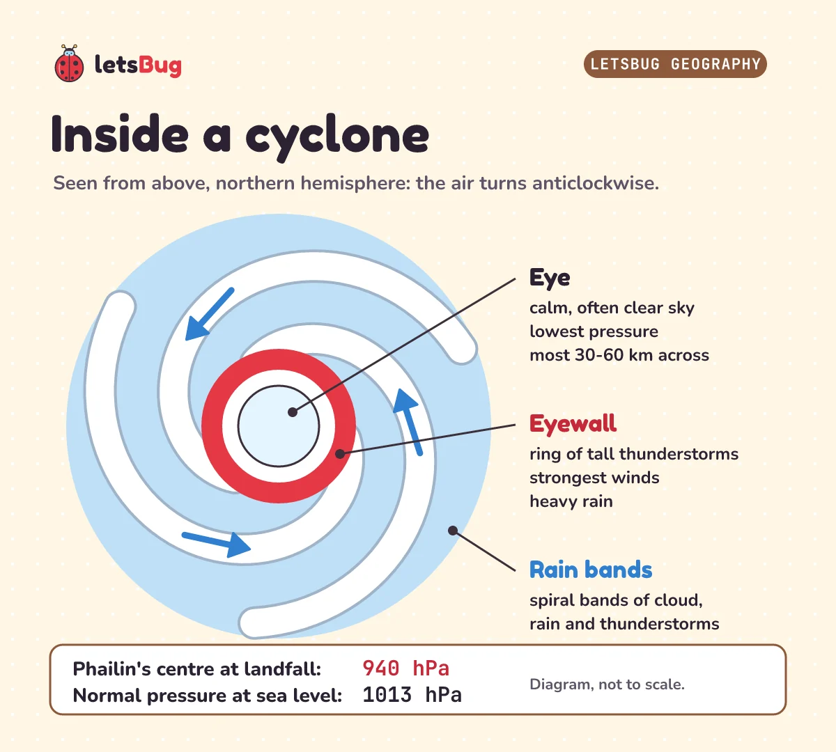
- The eye is the calm middle. IMD describes it as "a roughly circular area of comparatively light winds and fair weather found at the centre of a severe tropical cyclone." (Fair weather means dry, often with a clear sky.) "The eye is the region of lowest surface pressure", and most eyes are about 30 to 60 km across.
- The eyewall is the ring around the eye. NOAA: "The eyewall consists of a ring of tall thunderstorms that produce heavy rains and usually the strongest winds."
- The rain bands spiral outwards. NOAA calls them "Curved bands of clouds and thunderstorms that trail away from the eye wall in a spiral fashion."
The calm eye can fool people. NOAA warns: "Some people experiencing light wind and fair weather of an eye may think the hurricane has passed when actually, the storm is only half over, with dangerous eyewall winds returning shortly, this time from the opposite direction." If you're ever in a cyclone and it suddenly goes calm, stay inside.
How low is the pressure in the eye? When Phailin reached land, IMD estimated the pressure at its centre at 940 hPa, 66 hPa lower than the air around it. Normal pressure is much higher. The Met Office: "Standard sea-level pressure is 1013 hPa". That's 1013 − 940 = 73 hPa more than in Phailin's eye. Why 73 and not 66? The air around a cyclone is already below normal pressure: about 940 + 66 = 1006 hPa around Phailin. The Met Office explains why that matters: "The greater the difference in pressure (the pressure gradient), the stronger the wind." A deep low (very low pressure) makes fierce winds.
How do you read a cyclone track map?
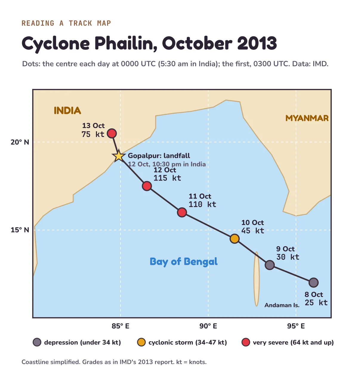
Forecasters plot a cyclone's path on a track map. Here's Phailin's, drawn from IMD's best track: the official list of where the storm's centre was, and how strong it was, every 3 hours.
Read it in four steps:
- Find the grid. Latitude (degrees north of the equator) runs up the side. Longitude (degrees east, measured round the Earth from London) runs along the bottom.
- Follow the dots in date order. Each dot is the centre of the storm at one time, here 0000 UTC (5:30 am in India) each day, except the first dot, at 0300 UTC on 8 October, when the depression formed. Phailin moved from 12.0° N, 96.0° E on 8 October to 19.2° N, 84.9° E at landfall: 7.2 degrees north and 11.1 degrees west. So it moved north-west, across the Bay of Bengal.
- Read the strength. The colour and the number show the wind speed in knots. It started as a depression (a weak area of low pressure) and grew.
- Spot the big jump. Between 10 and 11 October the wind rose from 45 to 110 knots at the dots, and IMD says "an increase in wind speed from 45 knots to 115 knots" from the morning of the 10th to the morning of the 11th. The dots are 24 hours apart: IMD's 115 knots came 3 hours after the 11 October dot, at 0300 UTC (8:30 am in India). That's called rapid intensification: a storm getting much stronger very fast.
Here are the numbers behind the map, from Table 1 of IMD's report:
| Time (UTC) | Centre | Wind (knots) | Pressure (hPa) | IMD grade |
|---|---|---|---|---|
| 8 Oct, 0300 | 12.0° N, 96.0° E | 25 | 1004 | depression |
| 9 Oct, 0000 | 13.0° N, 93.5° E | 30 | 1002 | deep depression |
| 10 Oct, 0000 | 14.5° N, 91.5° E | 45 | 996 | cyclonic storm |
| 11 Oct, 0000 | 16.0° N, 88.5° E | 110 | 946 | very severe cyclonic storm |
| 12 Oct, 0000 | 17.5° N, 86.5° E | 115 | 940 | very severe cyclonic storm |
| 12 Oct, about 1700 (landfall) | 19.2° N, 84.9° E | 115 | 940 | very severe cyclonic storm |
| 13 Oct, 0000 | 20.5° N, 84.5° E | 75 | 976 | very severe cyclonic storm |
Notice the pressure column: as the wind rose, the pressure at the centre fell, from 1004 hPa to 940 hPa. The stronger the storm, the deeper the low.
How are cyclones graded?
By their maximum sustained wind. Around India, IMD uses these grades:
| IMD grade | Wind (knots) | Wind (km/h) |
|---|---|---|
| Depression | 17 to 27 | 31 to 49 |
| Deep depression | 28 to 33 | 50 to 61 |
| Cyclonic storm | 34 to 47 | 62 to 88 |
| Severe cyclonic storm | 48 to 63 | 89 to 117 |
| Very severe cyclonic storm | 64 to 89 | 118 to 166 |
| Extremely severe cyclonic storm | 90 to 119 | 167 to 221 |
| Super cyclonic storm | 120 and above | 222 and above |
The 1999 storm was a super cyclonic storm: IMD gives its wind at landfall as "about 140 knots". IMD's 2013 report calls Phailin a very severe cyclonic storm. On the scale in IMD's current FAQ (above), its 115 knots falls in the extremely severe band, so you may see both names for the same storm.
In the Atlantic and the eastern Pacific, the US National Hurricane Center (NHC) uses the Saffir-Simpson scale instead: "a 1 to 5 rating based only on a hurricane's maximum sustained wind speed." Category 1 starts at 64 knots (119 km/h), and Category 5 is 137 knots (252 km/h) or higher. Be careful comparing the two scales. IMD says it averages the wind over 3 minutes, but "The National Hurricane Centre uses a 1-minute averaging time", so the same storm can get slightly different numbers. Roughly, Phailin's 115 knots would sit in Category 4 (113 to 136 knots).
Why are cyclones so dangerous?
A cyclone brings three hazards (dangers). IMD's report shows all three in Phailin: "It caused very heavy to extremely heavy rainfall over Odisha leading to floods, and strong gale wind leading to large scale structural damage and storm surge leading to coastal inundation over Odisha." (A gale is a very strong wind. Structural damage means damage to buildings. Inundation means flooding.)
- Strong wind. Phailin's winds reached 115 knots, strong enough to wreck buildings. Together with the floods, it damaged 419,052 houses in Odisha, IMD's report says.
- Heavy rain and floods. One town, Banki, got 38 cm (380 mm) of rain in 24 hours. The rain led to floods, and the floods killed 17 people in Odisha.
- Storm surge. The strong winds push the sea up and onto the land. NHC: "Storm surge is primarily caused by the strong onshore winds of a hurricane or tropical storm." Phailin's surge was 2 to 2.5 metres above the normal tide in Ganjam district, and salt water reached up to about one kilometre inland. In 1999, Mausam says, the surge raised the sea by "more than 20 feet", over 6 metres.
The surge is often the deadliest of the three. In the United States, NHC says storm surge "is currently the leading cause of fatalities from hurricanes" (fatalities means deaths). In Hurricane Ian, in 2022, NHC says storm surge caused 41 deaths.
How can we reduce the effects of a cyclone?
This is a classic exam question: Using a named example, explain how the effects of tropical storms can be reduced. There's a weak answer and a strong one.
A weak answer says: stop climate change. That doesn't answer the question. It can't protect anyone from the next storm already heading for the coast, and the question asks about a named storm. A strong answer links each measure to its effect, with real numbers from a named storm:
- Monitoring (watching the storm): satellites, ocean buoys (floating weather stations) and coastal weather stations tracked Phailin from the day it formed. IMD: "At the genesis stage, the system was monitored mainly with satellite observations, supported by meteorological buoys and coastal and island observations." (Genesis means birth.) As it neared land, the Doppler weather radar at Visakhapatnam, a city on India's east coast, a radar that measures rain and wind, sent a new picture every 10 minutes.
- Prediction (forecasting where and when it will hit): "IMD accurately predicted the genesis, intensity, track and point & time of landfall and also the adverse weather like heavy rainfall, gale wind and storm surge 4 to 5 days in advance."
- Planning (getting people out of danger): that warning gave time to move 983,642 people in Odisha to safety before the storm, and another 171,083 away from the floods after it. That's 1,154,725 people in all.
- The effect: 38 deaths in Odisha, against nearly 10,000 in 1999.
AQA's specification asks for exactly this: "Use a named example of a tropical storm to show its effects and responses." And: "How monitoring, prediction, protection and planning can reduce the effects of tropical storms." Protection means building to survive storms, for example strong cyclone shelters (buildings for people to stay in during a storm) and sea walls.
The two storms weren't identical: the 1999 one was stronger, with a far bigger surge. But warnings and evacuation (moving people away from danger) made a huge difference.
Your turn. These are the practice questions from the video. Try each one before you open the answers.
1) In 1999 the super cyclone killed nearly 10,000 people in Odisha. In 2013, Phailin's deaths in Odisha were 38. Using 10,000, what is the percentage decrease?
2) Why don't tropical cyclones form on the equator?
3) Which way do tropical cyclones spin in the southern hemisphere, and why?
Show the answers
1) The decrease is 10,000 − 38 = 9,962. Divide by the original number and multiply by 100: 9,962 ÷ 10,000 × 100 = 99.62, about 99.6%. Always divide by the original (the "before") number, not the new one.
2) The Coriolis effect is too weak near the equator. In-rushing air is hardly bent, so the storm can't start to spin, and without the spin the low pressure can't last. IMD says a band about 300 km wide on either side of the equator has no cyclones.
3) Clockwise. The Coriolis effect bends the air rushing in towards the low pressure to the left south of the equator, so the air swings round the centre clockwise.
Exam-style questions with model answers
The number in brackets is the marks. Each mark is one clear point.
Q1. State two conditions needed for a tropical cyclone to form. [2]
Model answer
Warm sea water, about 26.5 to 27 °C or warmer, down to about 50 m [1]. At least 500 km from the equator, so the Coriolis effect can make it spin [1]. (Moist air is also a correct condition.)
Q2. Explain why tropical cyclones spin anticlockwise in the northern hemisphere. [2]
Model answer
Air rushes in from high pressure towards the low pressure at the centre [1]. The Coriolis effect, caused by the Earth's spin, bends it to the right in the northern hemisphere, so it swings round the centre anticlockwise [1].
Q3. Describe the structure of a tropical cyclone. [3]
Model answer
A calm eye in the centre, with light winds and the lowest pressure [1]. The eyewall around it, a ring of tall thunderstorm clouds with the strongest winds and heavy rain [1]. Spiral rain bands of cloud and thunderstorms further out [1].
Q4. Using a named example, explain how monitoring, prediction and planning can reduce the effects of tropical cyclones. [4]
Model answer
Monitoring: satellites, buoys and radar tracked Cyclone Phailin (Odisha, India, 2013) as it formed and grew [1]. Prediction: IMD forecast where and when it would reach land 4 to 5 days ahead [1]. Planning: that gave time to evacuate almost a million people (983,642) in Odisha to safety [1]. So deaths in Odisha were 38, compared with nearly 10,000 in the 1999 super cyclone on the same coast [1].
Q5. In one day, Phailin's wind speed rose from 45 knots to 115 knots. Calculate the percentage increase. [2]
Model answer
Increase = 115 − 45 = 70 knots [1]. 70 ÷ 45 × 100 = 155.6, so about a 156% increase [1].
Questions people ask
Why do cyclones spin?
Because the Earth spins. Air rushes in towards the low pressure at the storm's centre, and the Coriolis effect bends it to the right north of the equator and to the left south of it. That makes the storm turn anticlockwise in the north and clockwise in the south.
Which way do cyclones spin in Australia?
Clockwise, like every tropical cyclone south of the equator. North of the equator, in India or the US, they spin anticlockwise.
What is the difference between a hurricane, a typhoon and a cyclone?
Only the place. They're the same kind of storm: a hurricane in the North Atlantic and the central and eastern North Pacific, a typhoon in the north-west Pacific, and a cyclone around India and Australia.
Why don't hurricanes form at the equator?
The Coriolis effect is too weak there to start the spin, and without the spin the low pressure can't last. IMD says a band about 300 km wide either side of the equator has no cyclones. One rare exception was Typhoon Vamei, which formed near Singapore in December 2001.
Does water drain the other way in the southern hemisphere?
No. The Coriolis effect is far too small to turn the water in a sink or toilet. The way it drains depends on the shape of the basin and how the water was moving, so you can find both directions in either hemisphere.
What is the eye of a cyclone?
The calm centre of the storm: light winds, often a clear sky, and the lowest pressure. Most eyes are about 30 to 60 km across. The strongest winds are in the eyewall, the ring of thunderstorms just around it.
Keep going
- Watch the full lesson, Why Do Cyclones Spin? How Hurricanes Form, or the one-minute Short: Why Do Cyclones Spin Anticlockwise in the North and Clockwise in the South?. More in letsBug Geography on YouTube.
- The episode before this one: why is the Sahara desert so dry? (episode 4: air pressure, wind from high to low, and the Coriolis effect).
- Read a real place's rain and temperature, month by month: how to read a climate graph (episode 3, with Mumbai's monsoon). Next in the series: climate change, the evidence and the causes.
Checked on 2 November 2026 against the 11 sources below. Every number was taken from the sources below. Every sum, percentage and track distance was worked out again in a Python script, and every quote was matched word for word with the source text.
Sources
- India Meteorological Department: Very Severe Cyclonic Storm Phailin over the Bay of Bengal (8-14 October 2013): A Report (best track, damage and warnings)
- India Meteorological Department: Frequently Asked Questions on Tropical Cyclones (definition, Coriolis force, grades, the eye, the 1999 super cyclone)
- IMD Mausam journal: Orissa super cyclone: A Synopsis (S. R. Kalsi, 2006; Orissa is the old spelling of Odisha)
- NOAA National Ocean Service: What is the difference between a hurricane and a typhoon?
- NOAA JetStream: Tropical cyclone introduction and Tropical cyclone structure
- NOAA National Hurricane Center: Saffir-Simpson Hurricane Wind Scale and Storm surge overview
- Met Office: High and low pressure
- AQA: GCSE Geography 8035 specification, Living with the physical environment (3.1.1.3 Weather hazards)
- CBSE: Class IX Social Science curriculum 2026-27