Yes, GPS works without internet. Your phone never sends anything to space. It only listens to the atomic clocks on the GPS satellites overhead, 20,200 km up (the system has about 31). Each signal says when it was sent, so your phone can turn its travel time into a distance. With distances to four satellites, it works out where you are, usually to within a few metres. In this post we follow that idea step by step, with real numbers, and see why the whole system would drift off by about 10 km a day without Einstein.
Key takeaways
- GPS is one-way: satellites broadcast, your phone listens. It needs no internet and no mobile signal.
- distance = speed of light × travel time. A signal that takes 0.07 s has come about 21,000 km.
- Distances to several satellites meet at one point: that's you. This is called trilateration.
- Your phone needs four satellites, not three: the fourth one corrects your phone's imperfect clock.
- Relativity makes the satellite clocks gain about 38 microseconds a day. Uncorrected, positions would drift about 10 km a day.
This post goes with letsBug Explains, episode 1. Watch it, or read on: the post adds the "without internet" details, India's own NavIC system and how accurate your phone really is.
Does GPS work without internet?
Yes. GPS satellites only send; your phone only receives. The radio signal comes straight from space, so it works in a forest, at sea or in a village with no network, as long as your phone can see enough of the sky.
What needs the internet is everything around GPS:
- The map itself. GPS gives your phone a position, a pair of numbers. Drawing the streets around that position needs map data, so download offline maps before you travel.
- Sharing your location. When an app shows your friends where you are, your phone sends that over the internet. That's the app, not GPS.
- A fast first fix. Satellites send their orbit details at only 50 bits per second, and the full navigation message takes 12.5 minutes to come down. So a phone starting from nothing can take a while to find you. Assisted GPS (A-GPS) downloads that same information over the mobile network, so the first fix is much quicker. Without a network, the phone just waits for it from the satellites.
GPS satellites are clocks with radios
The Global Positioning System is a fleet of about 31 working satellites, each circling the Earth twice a day at about 20,200 km. They fly in six orbital planes, arranged so that from almost anywhere on Earth at least four are above your horizon.
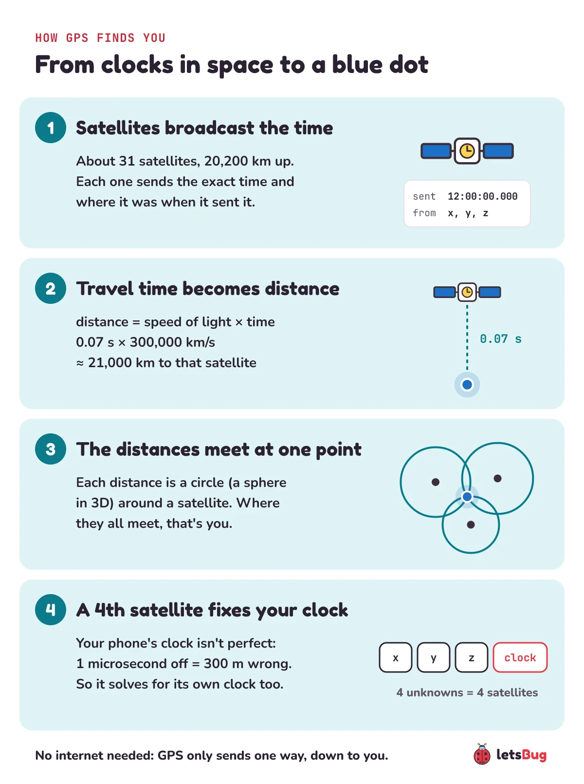
Each satellite carries atomic clocks and keeps broadcasting two things: the exact time the message was sent, and exactly where the satellite was when it sent it. That's all. Everything else happens inside your phone.
Turning time into distance
Your phone compares the time stamped on the message with the time it arrives. Radio waves travel at the speed of light, about 300,000 km every second, so:
distance = speed of light × travel time
d = c × t
Let's try real numbers. A signal sent at exactly noon arrives 0.07 seconds later:
d = 300,000 km/s × 0.07 s = 21,000 kmThat's a little more than the satellite's 20,200 km height, which makes sense: this satellite isn't straight overhead, it's off to one side, so its signal travels a slanted path. A signal from directly overhead takes about 0.067 s.
Trilateration: where the distances meet
One distance alone doesn't tell you where you are. Let's shrink the problem to a flat map first.
- If you're 10 km from a tower, you could be anywhere on a circle of radius 10 km around it.
- Add a second tower and a second distance: the two circles cross at just two points.
- A third circle passes through only one of them. That's you.
This is trilateration: finding a position from distances, not angles. Space has three dimensions, so the circles become spheres. One satellite puts you somewhere on a huge sphere. Two spheres meet in a circle. A third sphere cuts that circle at two points, and one of them is usually far out in space or deep inside the Earth, so it's thrown away. In a perfect world, three satellites would be enough.
Why your phone needs four satellites, not three
The world isn't perfect. The satellites carry atomic clocks; your phone has a cheap quartz clock that can easily be off by more than a millionth of a second. And a millionth of a second matters: in one microsecond, light travels about 300 metres. A clock error that small throws every distance off by 300 m, and the spheres no longer meet at one point.
The fix is clever. Your phone treats its own clock error as a fourth unknown. With four unknowns (the three position coordinates x, y, z and the clock error), it needs four measurements, so four satellites. It finds the one clock correction that makes all four spheres meet at a single point. That's how a phone gets away without an atomic clock.
The satellites can't get away with it. To find you to within a few metres, their clocks must agree to within a few billionths of a second: a timing error of just 10 nanoseconds is already 3 metres. Their atomic clocks tune a microwave signal to the exact frequency at which caesium or rubidium atoms switch between two energy states. For caesium that frequency is 9,192,631,770 cycles a second, and it's so steady that it now defines the second itself. Every atom of the same kind responds at exactly the same frequency, so these clocks keep near-perfect time.
Why GPS needs Einstein
Here's the strange part. Clocks on GPS satellites and clocks on the ground don't tick at the same rate, and Einstein's two theories of relativity explain both effects:
- Special relativity: a moving clock ticks more slowly. GPS satellites move at almost 4 km/s (about 14,000 km/h), so their clocks lose about 7 microseconds a day.
- General relativity: a clock deeper in a gravitational field ticks more slowly. Clocks on the ground sit deeper in Earth's gravity than clocks 20,200 km up, so the satellite clocks gain about 45 microseconds a day.
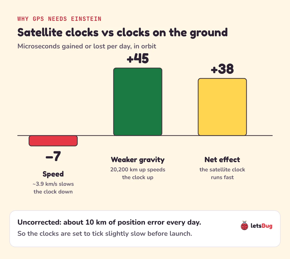
Put them together: 45 − 7 = 38 microseconds a day, fast. It sounds tiny, but light covers more than 11 km in 38 microseconds. Left uncorrected, position errors would build up by roughly 10 km every day. So engineers set each satellite clock to tick slightly slow before launch: 10.22999999543 MHz instead of 10.23 MHz. Once in orbit, relativity speeds it up to almost exactly 10.23 MHz, and ground stations correct what's left.
That makes GPS a daily, practical test of relativity: if Einstein were wrong, your map would be too.
Myth: GPS satellites track you
They don't, and they can't. GPS is one-way: the satellites broadcast, and your receiver listens and does all the maths itself. The satellites have no idea who is using them, or how many people are. If a company or another person knows where you are, it's because an app sent your position over the internet, or because your mobile network can see which towers your phone connects to. Neither of those is GPS.
GPS isn't the only system: India has NavIC
GPS is run by the United States (the U.S. Space Force operates it) and is free for anyone to use. Other countries run their own satellite navigation systems on the same idea: Russia's GLONASS, Europe's Galileo and China's BeiDou cover the whole world. India's NavIC, built by ISRO, is a regional system: it covers India and the region up to 1,500 km beyond its borders. Many phones listen to several systems at once, which means more satellites in view and a faster, steadier fix.
How accurate is GPS on your phone?
Under open sky, GPS-enabled smartphones are typically accurate to within about 4.9 metres (16 feet). It gets worse near tall buildings, bridges and trees for two reasons. Blocked signals leave fewer satellites to measure. Bounced signals take a longer path, so their travel time (and so the distance) looks longer than it is. That's why the blue dot sometimes jumps across the road in a city centre.
Use c = 300,000 km/s. (1) A signal takes 0.075 s to reach you. How far away is the satellite? (2) Your receiver's clock is off by 1 millisecond. Roughly how big is the distance error?
Show the answers
(1) 300,000 × 0.075 = 22,500 km.
(2) 300,000 km/s × 0.001 s = 300 km. That's why the fourth satellite matters.
For developers: location in the browser
A web page can ask for the user's position with the Geolocation API, navigator.geolocation.getCurrentPosition(). It only works on HTTPS pages, and only after the user allows it. The browser then uses the best source it has, which on a phone can be GPS. Building a web app that must keep working on a bad connection? Pair it with our post on detecting online and offline status in JavaScript.
Questions people ask
Does GPS use mobile data?
GPS itself doesn't: it only receives radio signals from satellites. Map apps use data to download map tiles and traffic, and Assisted GPS uses a little data to get your first position faster. With offline maps downloaded, navigation works with mobile data switched off.
How many satellites does GPS use?
The GPS constellation has about 31 working satellites in six orbital planes. Your phone needs signals from at least four at a time: three for position and one to correct its own clock. Using more makes the position steadier.
Why does GPS take long to find me sometimes?
A phone that has been off for a while has to collect the satellites' orbit details, which come down at only 50 bits per second. Assisted GPS speeds this up by downloading the same information over the mobile network. Indoors or between tall buildings, weak or reflected signals make it slower still.
Can GPS satellites see or track my phone?
No. GPS is a one-way broadcast. The satellites don't receive anything from your phone and don't know it exists. Tracking happens when an app shares your position over the internet, or through your mobile network's towers.
What is the difference between GPS and NavIC?
Both work the same way: time signals from satellites. GPS is the United States' worldwide system. NavIC is India's regional system, run by ISRO, covering India and up to 1,500 km around it. Phones that support both can use satellites from each.
Keep going
- Watch the full lesson, How Does GPS Work? It's All About Time, and the rest of letsBug Explains on YouTube.
- Another letsBug explainer, for coders: binary search in JavaScript and Python: find anything in a million items in 20 checks.
Sources
- GPS.gov: Space segment (altitude, orbits, number of satellites, U.S. Space Force)
- GPS.gov: GPS accuracy (smartphones: about 4.9 m under open sky)
- GPS.gov: Trilateration
- NASA Space Place: How does GPS work?
- Richard Pogge, Ohio State University: Real-world relativity: the GPS navigation system (−7, +45 and 38 microseconds a day; 10 km a day)
- Wikipedia: Global Positioning System (navigation message, 10.22999999543 MHz) and Assisted GNSS
- ISRO: IRNSS: NavIC (coverage up to 1,500 km beyond India)
- MDN: Geolocation API
- BIPM: the SI second (defined by the caesium-133 frequency, 9,192,631,770 Hz)
Every number in this post was checked against these sources, and the arithmetic was run in Python before publishing.